The National Emergency Planning for volcanic risk in the Phlegraean Fields
Over the past few years, the National Planning for volcanic risk in the Phlegraean Fields has been updated. In particular, by means of the Decree of the President of the Council of Ministers of June 24, 2016, the eruptive scenario, the red zone (exposed to the invasion of pyroclastic flows) and the yellow zone (affected by ash fallout) have been redefined based on studies by the scientific community. This redefinition preceded a phase of mutual sharing and consultation between the Civil Protection Department, the Campania Region, and the affected municipalities.
Planning activities were carried out based on the guidelines issued by the Head of the Civil Protection Department on February 2, 2015, "Indications to the components and operational structures of the National Service for the updating of emergency plans for the precautionary removal of the population of the red zone of the Vesuvian area," which also apply to the Phlegraean Fields area.
In 2019, the national exercise "Exe Flegrei 2019" was organized, in which procedures and operational strategy assumed in the national planning were tested. The exercise was also valuable for reshaping some operational decisions related to evacuating the population from the red zone.
(Last update: 3 January 2024)
The alert levels for the Phlegraean Fields indicate the volcano's activity status and mark the time span before the ressumption of a possible eruptive activity. The passage from one alert level to the following one is established on the basis of the monitored parameter variations and of possible ongoing phenomena. There are four alert levels:
• green level
• yellow level
• orange level
• red level
Every month, the Civil Protection Department organizes a videoconference with the Competence Centers in charge of monitoring activities and with the Campania Region to monitor the current phenomena and assess the volcanic risk. After the videoconferences, the alert level are declared.
Every six months the Civil Protection Department, after hearing the opinion of the Major Risks Commission - Volcanic Risk Sector, decides to confirm the alert levels and the operational phases (attention, pre-alarm and alarm) together with the Campania Region's civil protection structure.
Currently, the alert level for the Phlegraean Fields is yellow, and the operational phase adopted is "attention."
The complexity of the Phlegraean volcanic system, characterised by the presence of numerous craters and the absence of recent eruptions, means that it is not possible to predict with certainty when, how and where the next eruption will occur. Moreover, it is possible that the resumption of eruptive activity may occur from several mouths simultaneously, nor to predict the duration of the activity.
On the basis of a probabilistic study carried out - which considered the last 5 thousand years of activity of the Phlegraean Fields - emerged that, in the event of a reactivation of the volcano, there would be a 95% probability that an eruption smaller or equal to that of average size would occur. Therefore, the updating of the national civil protection planning is based on this type of eruption that provides for the following phenomena:
• The formation of an eruptive column made up of gas and shreds of incandescent lava, up to tens of kilometers high;
• Falling of large volcanic material in the area closest to the eruptive mouth, or of ashes and lapilli even tens of kilometers away, following the wind direction;
• Pyroclastic flows (avalanches of gas, ash and volcanic fragments) made up of the collapse of the eruptive column. These flows have high speeds and temperatures and can flow for several kilometres.
In addition, in the Phlegraean Fields particular explosive phenomena may occur due to the involvement of external water, known as phreatic explosions, in areas with intense hydrothermal activity (Solfatara/Pisciarelli area), or where there is currently significant availability of surface water, such as lake environments (Agnano), intracrateric lakes (Averno) and sea (Gulf of Pozzuoli).
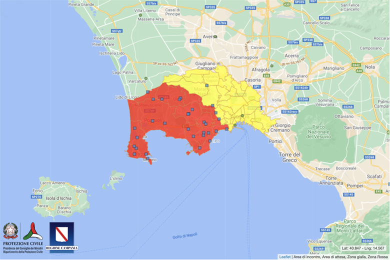
The red zone is the area for which preventive evacuation in case of "alarm" is the only protective measure for the population. In fact, the area is exposed to the risk of pyroclastic flooding, which, due to their high temperatures and speed, represent an extremely dangerous phenomenon for people. The red zone includes the municipalities of Pozzuoli, Bacoli, Monte di Procida and Quarto; part of the municipalities of Giugliano in Campania and Marano di Napoli; some of the neighborhoods of Naples: Soccavo, Pianura, Bagnoli, Fuorigrotta and part of the neighborhoods of San Ferdinando, Posillipo, Chiaia, Arenella, Vomero, Chiaiano and Montecalvario. Within the area there are approximately 500,000 residents.
The yellow zone is the area exposed to significant volcanic ash fallout in case of eruption. This area may require temporary removals of the population living in vulnerable buildings or challenging to reach due to ash accumulation. The yellow zone includes the municipalities of Villaricca, Calvizzano, Marano di Napoli, Mugnano di Napoli, Melito di Napoli, and Casavatore and 24 neighborhoods of Naples: Arenella, Avvocata, Barra, Chiaia, Chiaiano, Mercato, Miano, Montecalvario, Pendino, Piscinola, Poggioreale, Porto, San Carlo all'Arena, San Ferdinando, San Giovanni a Teduccio, San Giuseppe, San Lorenzo, San Pietro a Patierno, Scampia, Secondigliano, Stella, Vicaria, Vomero, and Zona Industriale. In the area, there are over 800 thousand residents.
In the "pre-alarm" phase, people may leave voluntarily, but with their own means. They can move to alternative accommodation (e.g. second home, to relatives or friends, rented house) and receive a State grant.
When the "alarm" state is declared, the entire population must leave the red zone and may decide to proceed independently or with assistance. The total estimated time for this operation is 72 hours (3 days), divided as follows:
• The first 12 hours to allow people to prepare and set up the necessary traffic control measures;
• The following 48 hours for the simultaneous but steady departure of the population from all the municipalities in the red zone, according to a schedule defined in the municipal plans;
• The last 12 hours, as a safety margin for the management of any critical issues and to allow the removal of the civil protection system operators.
For people who choose to be assisted, a twinning plan for the population removal from the municipalities in the red zone to the Italian Regions and Autonomous Provinces has been defined. In this case, the assisted transfer of people from the "Waiting Areas", defined in the Civil Protection Plan of each municipality, to the "Meeting Areas", identified outside the red zone, will take place by bus provided by the Campania Region. Successive transfer to the "Points of first reception" in the twinned Regions and Autonomous Provinces is planned in different ways (bus, train or ship) depending on the destination, to limit the impact on the mobility infrastructure and inconvenience to the population.
People who choose to move autonomously, with their own vehicle, must follow only the road routes established in the Removal Plan. Those who choose alternative accommodation provided by the State must continue towards the "Points of first reception" located in the twinned Regions and Autonomous Provinces; alternatively, those who choose to receive the contribution for autonomous accommodation can continue towards the alternative accommodation identified independently. The regulation of traffic during the autonomous removal phase will be managed through the activation of gates that will ensure the correct timing of the traffic flow out of the red zone.
On the occasion of the "Exe Flegrei 2019" exercise, specific signs were made that identifies:
• Waiting areas, set out in municipal Civil Protection Plans. In case of a declaration of "alert," Campania Region buses depart from here to conduct citizens to the meeting areas outside the red zone;
• The sign indicating the direction to reach the waiting area;
• The meeting areas, from which citizens who choose assisted transportation (via bus, train, ship) depart to reach the regions and autonomous provinces twinned with their municipalities. The meeting areas are:
1. Naples-Central Station Piazza Garibaldi;
2. Naples Port-Seaport Station;
3. Naples Afragola-Train Station Via Areana;
4. Giugliano in Campania-Istituto Don Diana Via Ripuaria;
5. Aversa-Train Station Piazza Mazzini;
6. Villa Literno-Train Station Piazza De Gasperi
• The point of first reception, in the twinned Regions and Autonomous Provinces. It is the place where citizens arriving from one of the municipalities in the Phlegraean Fields red zone arrive;
• The Command and Control Headquarters in San Marco Evangelista (CE) is where the National Service of Civil Protection activities are coordinated.
Resolution of the Regional Council No. 187 of April 19, 2023
Phlegraean Fields Volcanic Risk. Pathways for the assisted removal and autonomous removal of the population from the red zone
Resolution of the Campania Regional Council No. 547 of September 4, 2018
(Removal planning, approval of meeting areas and gates)
Decree of the President of the Council of Ministers of June 24, 2016
Provisions for updating emergency planning for volcanic risk in the Phlegraean Fields
(red zone, yellow zone and twinning Map)
Decree of the Head of Department of February 2, 2015
Indications to the components and operational structures of the National Service for the updating of emergency plans for the precautionary removal of the population of the red zone of the Vesuvian area
To know if you live, work or reside in the red or yellow zone, type your address in the search bar at the top right of the map. By clicking on the location identified, you will find more information on what is provided for your area by the Civil Protection plan: waiting area, meeting area, means of transport, Region or Autonomous Province twinned with your municipality and rules of conduct.
By clicking on the symbols representing in blue the waiting areas and in green the meeting areas, it is possible to read further information. By clicking on the corresponding item in the information box, it is possible to check both the information related to the areas (waiting or meeting areas) and that related to the zone (red or yellow zone).
From the "Manage layers" button, at the top left, it is possible to select and manage the information displayed on the map, hiding, centering or raising the opacity of each "layer" or information layer related to the red zone, yellow zone, waiting areas and meeting areas. In addition, with the "Base map" feature, you can change the background map (which by default is Google normal).
Finally, near the "Address search" bar there is the "Activate search filters" button that allows to filter the information on the map and combine it according to search preferences.
Here is available all the documentation about the items displayed on the map.